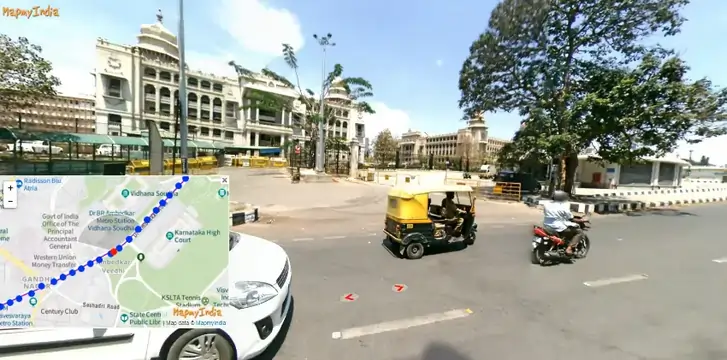
Google’s Street View has found a strong competitor in India with MapmyIndia’s Mappls, the country’s first map with 100% 360-degree panoramic street view with 4D Metaverse Maps Service.
After a decade of absence in the country, the internet giant has offered its Google Maps service again, but the company may now face a more challenging landscape in the digital maps service.
Cutting-Edge Metaverse Mapping
Mappl enables the generation of high-resolution geometries, road surfaces, traffic signs, and other objects with photo-realistic precision that allows for realistic simulations for driving. The tool essentially enables builders to create testing environments with real-world driving scenarios through lidar or imagery.
The technology can also be used in gaming and extended reality (XR) applications.
As you can see from the video above, MapmyIndia’s metaverse mapping platform can generate high-precision 4D maps that can be used for all sorts of simulation and AR/VR projects. But Mappl’s technology goes far beyond the metaverse as we know it.
Mappls “RealView” currently allows users to “travel” in India with a 360-degree panoramic view of streets, roads, tourist spots, highways, and even residential and commercial areas. The map has interactive 3D versions of famous landmarks all over the country and is also integrated with relevant videos.
The rich and accurate details on the map were made possible by the synergy of MapmyIndia’s 2D maps and the Indian Space Research Organization’s (ISRO) Earth observation data and satellite imagery. ISRO is India’s national space agency and the counterpart of the U.S National Aeronautics and Space Administration (NASA).
The rich data from MapmyIndia and ISRO is ushering in a realistic metaverse map experience for millions of people inside and outside India.

Mappls covers 100,000+ kilometers of areas in India, including Jaipur, Chennai, Pune, Hyderabad, Goa, Greater Mumbai, Delhi-NCR, Bengaluru, and more. The map’s vast and accurately reproduced areas are only a part of its entire repository.
Moreover, the wealth of data on the map can be helpful, especially for the public and private sectors, as well as application developers, of Mappl’s RealView technology-based action-programming interface (API).
India’s Pioneer in Digital Mapping
Rohan Verma, chief executive officer (CEO) of MapmyIndia, says that its service is more advanced and valuable for users compared to foreign map apps. He was also proud that the mapping service was made and developed fully by an Indian team. MapmyIndia is the country’s pioneer in digital mapping and has been delivering the service since 1995. The company has already served 2,000+ enterprises with its technology.
The Indian mapping service is free and available at Mappls, with an interface that shares many similarities with Google Map. Android and iOS users can also use this service by downloading the Mappls App.
Join our newsletter as we build a community of AI and web3 pioneers.
The next 3-5 years is when new industry titans will emerge, and we want you to be one of them.
Benefits include:
- Receive updates on the most significant trends
- Receive crucial insights that will help you stay ahead in the tech world
- The chance to be part of our OG community, which will have exclusive membership perks


